VisuGps3
Display GPS tracks on top of Google maps
Install / Use
/learn @vicb/VisuGps3README
VisuGps3
Display GPS tracks on top of Google maps.
Powered by:
This is the next version of VisuGps, one of my first web project. It has been rewritten to leverage the latest JS API form Google as the maps API v2 will be deprecated in 2013.
Supported features
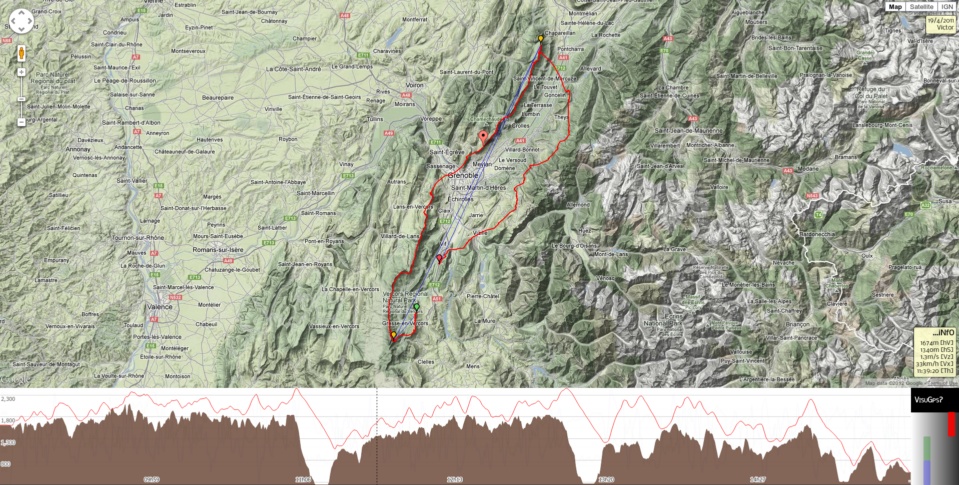
- Display a single or multiple tracks on top of a map,
- Display charts for elevation, horizontal & vertical speed,
- The track can be viewed in 3D
- on platforms where the GE plugin is supported,
- without any plugin if your browser support WebGL thanks to DoArama - based on Cesium
- Display markers for routes,
- Measure distances with the path plugin,
- Display restricted airspaces,
- Display skyways thanks to Michael von Känel,
- Switch to full screen mode,
- Topographic maps:
Roadmap
future versions
- use GeoJSON
Contributors
Credits
- Josh Livni: Parts of the earth plugin have been inspired by his Earth API library for Maps v3
- Shama explains how to integrate geoportal tiles within Google maps API.
- Marcin Grysko explains how the spain ign tile server works.
- Nianwei Liu for some Transverse Mercator projection code.
Related Skills
node-connect
350.8kDiagnose OpenClaw node connection and pairing failures for Android, iOS, and macOS companion apps
frontend-design
110.4kCreate distinctive, production-grade frontend interfaces with high design quality. Use this skill when the user asks to build web components, pages, or applications. Generates creative, polished code that avoids generic AI aesthetics.
openai-whisper-api
350.8kTranscribe audio via OpenAI Audio Transcriptions API (Whisper).
qqbot-media
350.8kQQBot 富媒体收发能力。使用 <qqmedia> 标签,系统根据文件扩展名自动识别类型(图片/语音/视频/文件)。
