Geotagging
Photography geotagging tool
Install / Use
/learn @jmlich/GeotaggingREADME
Introduction
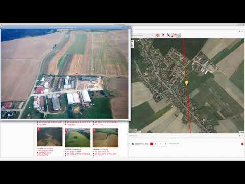
![]()
Geotagging is rather simple tool for manipulating with geographical information stored in JPEG images (in EXIF section). Your photos can be augmented by GPS coordinates by synchronization from track log files (*.gpx). The GPS coordinates can be also adjusted manually using Drag and Drop.
Installation
- Windows - download exe file from releases section
- Fedora - add COPR repository and install rpms
- Other Linux distributions - use flatpak
<a href='https://flathub.org/apps/details/com.github.jmlich.geotagging'><img width='240' alt='Download on Flathub' src='https://flathub.org/assets/badges/flathub-badge-en.png'/></a>

Contribute
- Translate to your language at transifex.
- Feel free to open issue
- Feel free to create merge request
Screenshots


Video tutorial
www.fit.vutbr.cz/study/DP/BP.php.cs?id=11578
Related Skills
node-connect
339.3kDiagnose OpenClaw node connection and pairing failures for Android, iOS, and macOS companion apps
frontend-design
83.9kCreate distinctive, production-grade frontend interfaces with high design quality. Use this skill when the user asks to build web components, pages, or applications. Generates creative, polished code that avoids generic AI aesthetics.
openai-whisper-api
339.3kTranscribe audio via OpenAI Audio Transcriptions API (Whisper).
commit-push-pr
83.9kCommit, push, and open a PR
